
Gaia current status
Skymap movie
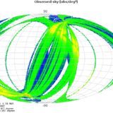
This “skymap” figure illustrates the areas of the sky that Gaia has already observed during these roughly five months of Commissioning.
The axes are Equatorial coordinates (right ascension and declination), wheras the color scale indicates the measurement density (as observations per square degree). Such density depends both on the sky in itself and on the “scanning law” followed by Gaia.
As we can see, there are areas where the density is significantly higher than in others. This is due to the special scanning laws in which Gaia has been operated during these Commissioning months. Specifically, there are two small areas with a very high density: the “ecliptic poles”, that is, the points on the celestial sphere crossed by an imaginary line perpendicular to the ecliptic plane – where the Earth travels on its orbit around the Sun.
This feature is intentional: The Commissioning phase was designed to run mostly on the so-called “ecliptic poles scanning law” (or EPSL), in which the spin axis of Gaia is completely fixed with respect to the Gaia-Sun axis (not doing any precession motion around it). With this we have been observing the ecliptic poles every day, allowing DPAC scientists to use the stars in such poles as references and perform essential diagnostics on the satellite, its instruments and the on-ground data processing systems. This EPSL mode can be either “trailing” or “leading”, that is, with the Gaia spin axis at -45 or +45 degrees with respect to the Gaia-Sun axis on the ecliptic plane.
We have also tested different manoeuvres and scanning modes of the satellite during these months. For example, setting the spin axis to zero degrees with respect to the Gaia-Sun axis (or “sun aspect angle”). Also, and specially, the “nominal scanning law” (NSL), which is the mode in which Gaia will operate during the nominal mission. This NSL has been tested twice so far – including the very recent “Galactic Plane scan”, in which we observe a very high number of stars almost following the Galactic Plane to stress-test all the systems.
The movie nicely illustrates all these manoeuvres. We start with the EPSL-trailing mode, followed by the EPSL-leading mode (including a short period with a sun aspect angle of zero degrees). A few days later we test the NSL mode, then coming back to EPSL-leading, and finally NSL scanning close to the Galactic Plane.
These “skymap” figures are automatically determined by the Initial Data Treatment from the data processed by this system every day, using the star measurements and the attitude information provided by the satellite. The composed image and movie have been prepared by the UB team.
See the same video with scanning law annotation


